


Geocam Free
Beschreibung von Geocam Free
Geocam by Wazar is the leading geophoto and video application for Android. It uses augmented reality to show on top of your camera a layer of geographical information such as Compass orientation, GPS position and different phone inclinations like a theodolite optical instrument.
What you can do with Geocam:
* Geo-Pictures: photos that have an extra layer of geographical data such as GPS position, compass orientation, pitch, roll, altitude, etc. This data is added into the EXIF metadata and can selectively be drawn on images as an overlay. You can see all you pictures on Google Maps or on Google Earth on your personal computer with the export feature. You can share those albums with anyone who can run Google Earth.
* Geo-Videos (Pro only): the first and only app to let you record videos with an embed layer of geographical data. A useful addition to pictures. With Geocam Studio (available on geocam.wazar-apps.com), customize and export these videos and share them.
* Bearings: Geocam is an accurate measure tool. It shows your compass orientation (choose between magnetic or geographic North), your inclination and elevation with readable cursors (like a cockpit HUD). It can be used in terrain mapping, on a glide, sailing, mountain biking...
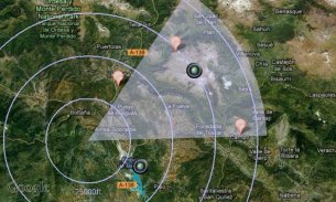
* Geo-Caching: prepare a list of key places in an area and view them with your camera on augmented reality: name, distance. You will not require a data connection offline so it can be used when hiking abroad, when visiting another city... This will help you make sure you are going in the right direction and give you remaining distance. You can also add markers during your hike with the "Add here" option, for example to flag the base camp, a water source, or anything interesting you find on your way.
* Measurements: Evaluate the distance to any object with the triangulation feature. You can also measure its height once the distance is known. This is not done by showing any unreadable cursor on the screen, but with mathematical formulas. Choose between metric and imperial measure systems.
Geocam supports extensive customisation including:
* Selecting which indicators to display on the HUD and whether to save them or not on pictures
* Metric and imperial systems
* GPS Formats: Decimal degrees, degrees/minutes/second, MGRS, UTM
* True north or magnetic north
* Degrees or Mils compass readings
* Percentage or degree slopes
* Calibrating "zero" pitch and roll to custom values to measure differences
* Different themes including a "cockpit" style or a "hi-vis" style
This is a free edtition, and with Geocam Pro, you get:
* No Ads
* Record and playback augmented video. This is a powerful tool in addition to Geophoto to record the topology of any area for further reference, as you can add your own audio commentary. Augmented video is an exclusivity of Geocam by Wazar.
* Export KMZ files to Google Earth, to display your pictures and markers in their original location and orientation, and share them easily.
IMPORTANT NOTE: If you are facing an issue, we cannot help you if you only leave a review. Do get it touch by email so we can hep you. We do reply to all emails and regularly push out fixes to reported problems. By all means please do get in touch if you are experiencing difficulties.
GeoCam von Wazar ist der führende geophoto und Video-Anwendung für Android. Es nutzt Augmented Reality auf der Oberseite der Kamera eine Schicht von geografischen Informationen wie Kompass Orientierung, GPS-Position und andere Telefon Neigungen wie ein Theodolit optisches Instrument zu zeigen.
Was Sie mit GeoCam tun:
* Geo-Bilder: Fotos, die eine zusätzliche Schicht von geografischen Daten wie GPS-Position, Kompass Orientierung, Nick-, Roll-, Höhe, usw. Diese Daten hinzugefügt wird, in die EXIF-Metadaten und kann selektiv gezeichnet werden auf Bilder als Overlay haben. Sie können alle Sie Bilder auf Google Maps oder Google Earth auf Ihrem PC mit der Export-Funktion zu sehen. Sie können diese Alben mit jedem teilen, der Google Earth laufen kann.
* Geo-Videos (Pro): die erste und einzige App, die Sie Videos aufzeichnen mit einer Einbettungsschicht von geografischen Daten zu lassen. Eine sinnvolle Ergänzung zu den Bildern. Mit GeoCam Studio (auf geocam.wazar-apps.com), anpassen und diese Videos exportieren und sie teilen.
* Lager: GeoCam ist ein genaues Maß Werkzeug. Es zeigt Ihre Kompassausrichtung (wählen Sie zwischen magnetischen oder geographischen Norden), Ihre Neigung und Höhe mit lesbaren Cursor (wie ein Cockpit HUD). Es kann im Terrain-Mapping verwendet werden, auf einem Gleitflug, Segeln, Mountainbiken ...
* Geo-Caching: eine Liste der wichtigsten Orte in einem Gebiet vorzubereiten und sie mit Ihrer Kamera auf Augmented-Reality-Ansicht: Name, Entfernung. Sie werden keine Datenverbindung offline benötigen, damit es verwendet werden kann, wenn sie im Ausland wandern, wenn eine andere Stadt besuchen ... Dies wird helfen, Sie sicherstellen, dass Sie in die richtige Richtung gehen und geben Ihnen die verbleibende Entfernung. Sie können auch Marker während der Wanderung hinzufügen mit "Add hier" Option, zum Beispiel, um Flagge das Basislager, eine Wasserquelle, oder irgendetwas Interessantes auf dem Weg zu finden.
* Maße: den Abstand zu einem Objekt mit der Triangulation Funktion auswerten. Sie können auch seine Höhe zu messen, wenn der Abstand bekannt ist. Dies ist nicht durch zeigt alle unleserlich Cursor auf dem Bildschirm, aber mit mathematischen Formeln getan. Wählen Sie zwischen metrischen und zölligen Maß Systeme.
GeoCam unterstützt umfangreiche Anpassungen, einschließlich:
* Auswahl der auf dem HUD, welche Indikatoren angezeigt werden und ob sie oder nicht auf Bilder zu speichern
* Metrische und zöllige Systeme
* GPS-Formate: Dezimalgrad, Grad / Minuten / Sekunden, MGRS, UTM
* Echte Norden oder magnetischen Norden
* Degrees oder Mils Kompass Lesungen
* Prozentsatz oder Grad Pisten
* Kalibrier "Null" Nick- und Wankbewegungen, um benutzerdefinierte Werte Unterschiede zu messen
* Verschiedene Themen, darunter ein "Cockpit" Stil oder ein "hallo-vis" Stil
Dies ist ein kostenloses edtition und mit GeoCam Pro erhalten Sie:
* Keine Werbung
* Aufnahme und Wiedergabe Augmented Video. Dies ist ein leistungsfähiges Werkzeug neben Geophoto die Topologie von Flächen für weitere Referenz zu erfassen, wie Sie Ihre eigenen Audio-Kommentar hinzufügen. Augmented Video ist eine Exklusivität von GeoCam von Wazar.
* Export KMZ-Dateien in Google Earth, sie Ihre Bilder und Markierungen in ihrer ursprünglichen Position und Orientierung, und leicht zu teilen anzuzeigen.
WICHTIGER HINWEIS: Wenn Sie ein Problem konfrontiert sind, können wir Ihnen nicht helfen, wenn Sie einen Kommentar hinterlassen. Verstehen Sie es per E-Mail berühren, damit wir Sie hep können. Wir antworten auf alle E-Mails und regelmäßig schieben Fixes gemeldete Probleme. Mit allen Mitteln in Berührung komme bitte, wenn Sie Schwierigkeiten haben.
Geocam Free – Version 5.34
(10-04-2020)Geocam Free – APK Informationen
APK Version: 5.34Paket: com.mywayNeueste Version von Geocam Free
Weitere Versionen


Apps in derselben Kategorie
 3.694.324.073.674.394.41
Das könnte dir auch gefallen...


